
Remote Sensing Research
Research by the FPC has discovered the strong relationship between leaf area and forest productivity in both pine and eucalyptus stands. This relationship enables foresters to use leaf area index (LAI) as a parameter to predict stand growth and response to silvicultural treatments. LAI can be estimated visually from the ground as well as via LiDAR techniques, developed via FPC research. However, satellite remote sensing data from platforms such as Landsat and Sentinel-2 can also provide LAI information with greater time frequency and lower cost. Previous research by the FPC and collaborators (Cohrs et al., 2020) shows that the simple ratio index obtainable from Landsat and Sentinel-2 can be used to accurately estimate LAI and can be an effective and low-cost tool for estimating LAI at the stand scale. Recent FPC projects have also developed potentially more sensitive LAI models using advanced convolutional neural networks, informed by LiDAR data provided by coop members. In addition, FPC researchers have begun developing tools for generating satellite-derived stand canopy and understory indicators with rapid turnaround and low computational overhead using the emerging Google Earth Engine system. Further efforts are being directed towards providing LAI, understory, and other data and maps to forester practitioners in easily user-accessible formats via ArcGIS Image services and other online venues.

Techniques for retrieving Leaf Area Index (LAI) and other stand indicators have been previously developed by FPC researchers and collaborators. These tools have been further adapted into the Earth Engine environment using both the Sentinel-2 and Landsat satellite networks. These tools allow for simple, rapid and wide-scale processing of, for example, wintertime loblolly pine LAI maps over its native range, as shown above for 2020 using Senintel-2 imagery at 10 m resolution. Insets show finer detail.
Estimating Leaf Area and Understory from Satellite and Airborne Derived Data
Given the high temporal resolution of Landsat and Sentinel-2 data, estimates of competing understory LAI in pine plantations can be made specifically for competing deciduous vegetation in certain environments by comparing spring and winter LAI estimates. FPC research has also demonstrated airborne LiDAR can be used to accurately estimate LAI in the canopy of pine and eucalyptus plantations as well as in the understory (Sumnall et al., 2021).

Canopy LAI (L) and deciduous understory density (R) for RW19 experimental site in Appomattox, VA, retrieved via new Earth Engine process for Sentinel-2 data
The FPC has acquired airborne LiDAR data from multiple locations across the southeastern United States and in South America since 2008 and most recently in 2022. Using these datasets, we have developed and validated a number of methods estimating fundamental mensuration data at the individual-tree and stand-level (e.g. LAI, height, 3D crown dimensions, and 3D stem dimensions). Methods for the classification and mapping of individual canopy elements and competing vegetation by using 3D clustering techniques have been further developed. An evolving set of tools has been made available to FPC members for the analysis of airborne LiDAR in order to estimate various area-based metrics, which is available from the FPC website.
Canopy LAI is now available for loblolly in the SE U.S. based on satellite imagery, with work ongoing to expand to more species and other regions. Research at the FPC has lately produced automated tools for rapidly retrieving deciduous understory density using satellite imagery at 10 m resolution based on well-established seasonal differencing techniques. A special project in 2022 demonstrated understory mapping capability over millions of stand acres of FPC member organizations, giving a first-ever opportunity for ground-truth refinement. Canopy and Understory density, paired with additional data on soil fertility, could form a powerful suite of information for foresters to plan stand management.
Utilizing Airborne LiDAR Data

A classified tree stem highlighted in red at Kennedy tree farm, VA, extracted from UAV LiDAR data. Stem diameter estimated as 11.1 in.
Recent advancements in technology have enabled the use of unmanned aerial vehicles (UAVs) as a remote sensing platform. The FPC has developed methods designed to facilitate the use of these platforms and provide members with practical, high-detail and accurate forest measurements.
Since 2017 UAV LiDAR data has been acquired for various FPC research sites. The UAV LiDAR dataset provides a very high density of returns (>500 pulses per m2) compared to a traditional acquisition (~20 pulses per m2), which improves the estimation of the physical attributes of individual trees, such as height and crown dimensions. Research has yielded the direct classification of tree stems, allowing direct estimates of stem diameter at multiple heights (illustrated left).
Research into isolating individual trees, has yielded promising results, where over 85% of stems can be located in typical loblolly pine plantations. Competing understory vegetation can be classified by exploiting its different 3D distribution of returns in contrast to overstory trees. Research into the local neighbored surrounding each stem has yielded accurate predictive models for estimating both DBH and stem volume (RMSE ≤3 cm and ≤0.06 m3) (Sumnall et al., 2023).
The ongoing nature of the research and the use of new technologies such as UAV LiDAR allows us to assess its capabilities for mapping both overstory and understory components, and the implications for targeted management activities. UAV LiDAR can potentially provide repeated acquisitions quickly, which has a great potential for the detection of changes at multiple scales.
Terrestrial Laser Scanning Research

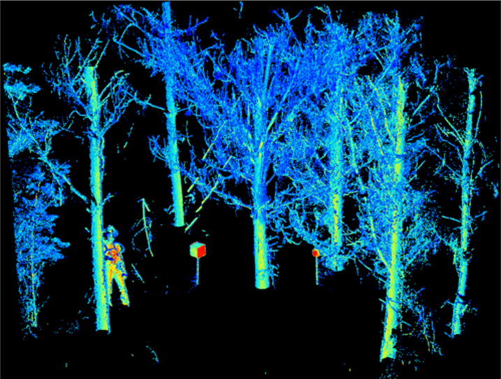
‘Real’ colored points from terrestrial laser scanning.
High-resolution data can also be acquired from the ground by using Terrestrial Laser Scanning (TLS) systems. The acquisition of TLS data can provide quantitative measurements in plantation forests of various stocking levels beneath the forest canopy. TLS data allows for the visualization of suppressed trees and competing vegetation of various sizes. A method of delineating individual stems was designed through classifying 3D neighborhoods based on Hough-transformations to find the conical shapes within the point-cloud. In addition, estimates of the volume of photosynthetic material, height to the living canopy and understory 3D extent could be made.
Estimates of LAI from TLS are potentially more accurate than traditional optical measurements but require a different method than that developed for ALS due to the difference in sensor position. The TLS approach quantifies the permeability of the canopy from the sensor position. Research has demonstrated that returns from leaf or bark can be separated based on the return intensity signal (from a green laser) which allows the automatic classification of points (illustrated below). The capabilities of TLS hold a great deal of potential in quantifying the locations of and true area of leaf material within an area of interest for the canopy or understory.

Classified and defoliated individual tree stems from terrestrial laser scanning.